Today our topic is applications of remote sensing, the guest lecturer Lela Prashad has shared an amazing presentation on "Remote Sensing of Cities from Space". The pictures below are captured in today's class when we are communicating with Lela.
Explorations of Remote Sensing Data
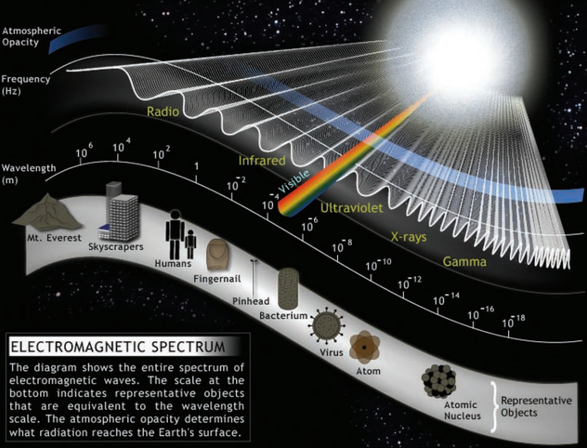
Urban remote sensing is a powerful tool to assess and compare both how urban forms evolve and how applied solutions to urban problems are developed. Analyses can involve in-depth cross-comparisons of cities across geographic areas, nation-wide or globally. Each remote sensing "measurement" is a synoptic point in time and space that can have high temporal resolution, and allows for the acquisition of data that may be too costly to collect in-situ. The data is also not constrained by political boundaries or hindered by differing collection methods. Quantitative as well as qualitative comparisons can be made for past, present, or future temporal and spatial patterns of urban development trajectories. By incorporating social and economic data with remote sensing analysis—such as public health, population, industrial data, or patterns of vulnerability—issues of sustainability can be analyzed and studied. The electromagnetic spectrum is a key point of remote sensing's development in the future. For example, if the sensing technology is developed enough to detect the specified viruses in urban area, less people will die of it. The following picture shows the electromagnetic spectrum of some things in the universe.
As a student focused on urban science and data science, I am always trying to figure out how to make cities better based data. Remote sensing comes to be a crucial form of data collection, processing and explaining, especially on the level of geographic which is a basic frame for urban planning. Urban planning can achieve many gains through closer connection to the remote sensing community and use of modern remote sensing technologies. While some projects, such as the European Urban Atlas extensively use remotely sensed data, the gradual commercialization of satellite or airborne earth observation since the 1970s and its prospects on performance and effectiveness have greatly expanded.
Urban planning is a highly complex process aiming at a conceptual anticipation of future situations. Thus it needs a responsible balancing of advantages and disadvantages from a holistic perspective. The most important condition for the balancing of pro’s and con's and a subsequent development of strategic orientation for future planning activities is knowledge: knowledge on the inhabitants of the city and the physical urban environment as well as change over time.
Urban planning is a highly complex process aiming at a conceptual anticipation of future situations. Thus it needs a responsible balancing of advantages and disadvantages from a holistic perspective. The most important condition for the balancing of pro’s and con's and a subsequent development of strategic orientation for future planning activities is knowledge: knowledge on the inhabitants of the city and the physical urban environment as well as change over time.
Some Thoughts of My Project Inspired by Remote Sensing
As I mentioned an overview of my project idea in my last post, I'm thinking about doing pace speed tracking of people in New York City, and figuring out those factors which cause the differences between people's average speed in different areas. Although there are still many aspects of my project need to be clear, yet I got inspired by remote sensing about some related factors. These remote sensing data or imagery may make the project.
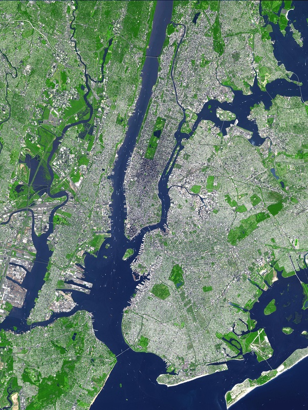
First of all, inside those remote sensing data links, I found there is vegetation covering remote sensing, for the urban area in NYC like Manhattan, those parks with large amount of vegetations will be outstanding because areas like main streets are almost covered with no vegetations. So I am able to evaluate my assumption that "people walk slower near park areas", this assumption is based on considering people feel relaxed when they walk in parks. There is a vegetation remote sensing picture below.
First of all, inside those remote sensing data links, I found there is vegetation covering remote sensing, for the urban area in NYC like Manhattan, those parks with large amount of vegetations will be outstanding because areas like main streets are almost covered with no vegetations. So I am able to evaluate my assumption that "people walk slower near park areas", this assumption is based on considering people feel relaxed when they walk in parks. There is a vegetation remote sensing picture below.
Secondly, I assumed that if there are a lot of people moving around an area, people will walk faster because more people cause higher stress level around. It is just a assumption, after I get the data of pace speed, I will do comparison between different factors. General speaking, those places filled with active people will stay in a relatively high temperature, it is based on the infrared ray radiation. When the remote sensing projects are doing the urban heat map sensing like urban heat island research, there will be temperature or heat distribution maps for the urban area. We can suppose places with higher temperature are gathered more people. Like the two maps shown below.
It would be very helpful by comparing the pace tracking result with these two remote sensing outputs.
